Make a donation
Gear up for your next adventure:
As an Amazon Associate, this site earns from qualifying purchases at no extra cost to you.
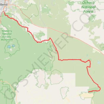
Bend to Alvord Section 1 - Bend to Christmas Valley Sand Dunes
- Distance: 98.6 mi
- Elevation gain: 2,910 ft
- Maximum elevation: 5,115 ft
- Elevation loss: 2,510 ft
- Minimum elevation: 3,911 ft
Interactive trail map
Make a donation
Gear up for your next adventure:
As an Amazon Associate, this site earns from qualifying purchases at no extra cost to you.
Trail profile
- Distance: 98.6 mi
- Elevation gain: 2,910 ft
- Maximum elevation: 5,115 ft
- Elevation loss: 2,510 ft
- Minimum elevation: 3,911 ft
Make a donation
Gear up for your next adventure:
As an Amazon Associate, this site earns from qualifying purchases at no extra cost to you.
About this trail
Name: Bend to Alvord Section 1 - Bend to Christmas Valley Sand Dunes trail, distance, elevation, map, profile, GPS track
Start: 60599, China Hat Road, Bend, Deschutes County, Oregon, 97702, United States (43.99910 -121.31242)
End: Lake County, Oregon, 97736, United States (43.35369 -120.37188)
Coordinates: 43.35369 -121.31242 43.99910 -120.24474
Topography: Bend topographic map, elevation, terrain
Make a donation
Gear up for your next adventure:
As an Amazon Associate, this site earns from qualifying purchases at no extra cost to you.
Other hiking, mountain biking, running and outdoor activity trails
Click on a trail to view its statistics, map and profile.
Peter Skene Ogden Trail to the Paulina Lake
United States > Oregon > Deschutes County
Hike to the Paulina Lake by the Peter Skene Ogden Trail along the Paulina Creek via McKay Crossing Falls and Paulina Falls in the Newberry National Volcanic Monument and the Deschutes National Forest. #Hiking #Mountain #River #Forest #Falls #Nature #Volcano #Lake
Distance: 8.5 mi • Elevation gain: 2,073 ft • Maximum elevation: 6,358 ft
Northern part of the Pacific Crest Trail (PCT)
United States > Oregon > Klamath County
Hike on the Pacific Crest National Scenic Trail from Crater Lake to Canada Border through Oregon and Washington along the Sierra Nevada and Cascade mountain ranges. #Hiking #Mountain #SierraNevada #Cascade #Nature #Forest #Park #PCT
Distance: 744.6 mi • Elevation gain: 145,367 ft • Maximum elevation: 7,569 ft
Bend to Alvord Section 2 - Christmas Valley to A6 Intruder Route
United States > Oregon > Lake County
Distance: 24.6 mi • Elevation gain: 801 ft • Maximum elevation: 4,692 ft