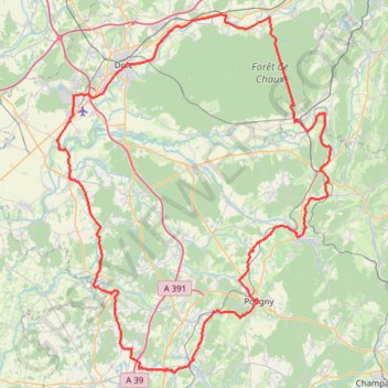
Tour du Jura à vélo loisirs - Dole
- Distance: 96.5 mi
- Elevation gain: 3,953 ft
- Maximum elevation: 1,276 ft
- Elevation loss: 3,953 ft
- Minimum elevation: 620 ft
Interactive trail map
Trail profile
- Distance: 96.5 mi
- Elevation gain: 3,953 ft
- Maximum elevation: 1,276 ft
- Elevation loss: 3,953 ft
- Minimum elevation: 620 ft
About this trail
Name: Tour du Jura à vélo loisirs - Dole trail, distance, elevation, map, profile, GPS track
Coordinates: 46.75584 5.38616 47.14689 5.82496
Other hiking, mountain biking, running and outdoor activity trails
Click on a trail to view its statistics, map and profile.
PT23DS2 Lörrach → Cadaqués
Germany > Baden-Württemberg > Landkreis Lörrach > Lörrach (Kernstadt)
Distance: 652.9 mi • Elevation gain: 43,077 ft • Maximum elevation: 4,938 ft
Riethoven naar Oostenrijk
Netherlands > North Brabant > Riethoven > Eind
Distance: 573.0 mi • Elevation gain: 44,715 ft • Maximum elevation: 6,224 ft