West Ridge Trail and Thompson Park
Saturna Island Hike
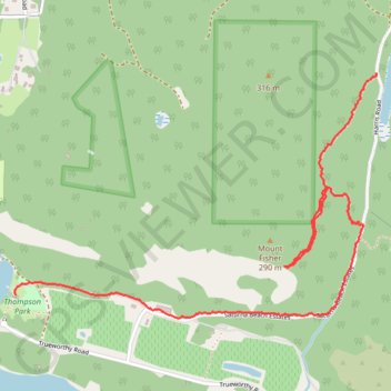
- Distance: 2.2 mi
- Elevation gain: 358 ft
- Maximum elevation: 879 ft
- Elevation loss: 896 ft
- Minimum elevation: 16 ft
- Moving time: 1 h 1 m
- Moving speed: 2.1 mph
- Maximum speed: 4.5 mph
- Total time: 1 h 29 m
- Global speed: 1.5 mph
Interactive trail map
Trail profile
- Distance: 2.2 mi
- Elevation gain: 358 ft
- Maximum elevation: 879 ft
- Elevation loss: 896 ft
- Minimum elevation: 16 ft
- Moving time: 1 h 1 m
- Moving speed: 2.1 mph
- Maximum speed: 4.5 mph
- Total time: 1 h 29 m
- Global speed: 1.5 mph
About this trail
Name: West Ridge Trail and Thompson Park trail, distance, elevation, map, profile, GPS track
Coordinates: 48.77576 -123.20012 48.78448 -123.18062
Other hiking, mountain biking, running and outdoor activity trails
Click on a trail to view its statistics, map and profile.
Brown Ridge Goat Hike
Canada > British Columbia > Capital Regional District > Southern Gulf Islands Electoral Area
Gulfs Islands National Park Reserve, Saturna Island
Distance: 1.7 mi • Elevation gain: 715 ft • Maximum elevation: 1,289 ft
Walk down from Mount Warburton
Canada > British Columbia > Capital Regional District > Southern Gulf Islands Electoral Area
Warburton Pike Mountain Hike, Gulfs Islands National Park Reserve, Saturna Island
Distance: 1.2 mi • Elevation gain: 20 ft • Maximum elevation: 1,289 ft