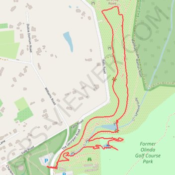
Dandenong Ranges Botanic Garden
- Distance: 2.1 mi
- Elevation gain: 371 ft
- Maximum elevation: 1,952 ft
- Elevation loss: 367 ft
- Minimum elevation: 1,617 ft
- Moving time: 1 h 5 m
- Moving speed: 1.9 mph
- Maximum speed: 4.8 mph
- Total time: 1 h 26 m
- Global speed: 1.5 mph
Interactive trail map
Trail profile
- Distance: 2.1 mi
- Elevation gain: 371 ft
- Maximum elevation: 1,952 ft
- Elevation loss: 367 ft
- Minimum elevation: 1,617 ft
- Moving time: 1 h 5 m
- Moving speed: 1.9 mph
- Maximum speed: 4.8 mph
- Total time: 1 h 26 m
- Global speed: 1.5 mph
About this trail
Name: Dandenong Ranges Botanic Garden trail, distance, elevation, map, profile, GPS track
Coordinates: -37.85251 145.36791 -37.84420 145.37319
Other hiking, mountain biking, running and outdoor activity trails
Click on a trail to view its statistics, map and profile.
Secret Garden, Dandenong Ranges Botanic, Pirianda
Australia > Victoria > Melbourne
Distance: 9.2 mi • Elevation gain: 1,506 ft • Maximum elevation: 1,932 ft
Dandenong Ranges Botanic Garden loop
Australia > Victoria > Melbourne
Distance: 2.6 mi • Elevation gain: 492 ft • Maximum elevation: 1,952 ft
Secret Garden, Dandenong Ranges Botanic Garden
Australia > Victoria > Melbourne
Distance: 8.4 mi • Elevation gain: 1,053 ft • Maximum elevation: 1,949 ft
Dandenong Ranges National Park Ridgewalk
Australia > Victoria > Melbourne > Tremont
Distance: 13.7 mi • Elevation gain: 3,287 ft • Maximum elevation: 1,939 ft
Secret garden, Dandenong Ranges botanic
Australia > Victoria > Melbourne
Distance: 6.1 mi • Elevation gain: 1,102 ft • Maximum elevation: 1,932 ft
Dandenong ranges botanical gardens
Australia > Victoria > Melbourne
Distance: 4.0 mi • Elevation gain: 748 ft • Maximum elevation: 1,955 ft
Dandenong ranges botanical garden
Australia > Victoria > Melbourne
Distance: 5.7 mi • Elevation gain: 433 ft • Maximum elevation: 1,952 ft
Former Olinda Golf Course Park
Australia > Victoria > Melbourne
Distance: 1.5 mi • Elevation gain: 341 ft • Maximum elevation: 1,926 ft
Three gardens
Australia > Victoria > Melbourne
Distance: 7.3 mi • Elevation gain: 1,650 ft • Maximum elevation: 1,932 ft