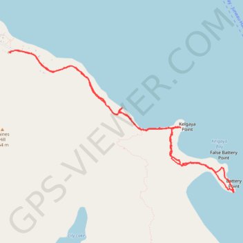
Battery Point Trail in Alaska USA
- Distance: 4.7 mi
- Elevation gain: 843 ft
- Maximum elevation: 233 ft
- Elevation loss: 827 ft
- Minimum elevation: 3 ft
- Moving time: 1 h 49 m
- Moving speed: 2.6 mph
- Maximum speed: 7.5 mph
- Total time: 1 h 54 m
- Global speed: 2.5 mph
Interactive trail map
Trail profile
- Distance: 4.7 mi
- Elevation gain: 843 ft
- Maximum elevation: 233 ft
- Elevation loss: 827 ft
- Minimum elevation: 3 ft
- Moving time: 1 h 49 m
- Moving speed: 2.6 mph
- Maximum speed: 7.5 mph
- Total time: 1 h 54 m
- Global speed: 2.5 mph
About this trail
Name: Battery Point Trail in Alaska USA trail, distance, elevation, map, profile, GPS track
Start: 702, Beach Road, Haines, Alaska, 99827, United States (59.22160 -135.40503)
End: Beach Road House, Beach Road, Haines, Alaska, United States (59.22143 -135.40645)
Coordinates: 59.20772 -135.40645 59.22161 -135.36361
Topography: Haines topographic map, elevation, terrain