Thank you for supporting this site ❤️
Make a donation
Make a donation
Gear up for your next adventure:
As an Amazon Associate, this site earns from qualifying purchases at no extra cost to you.
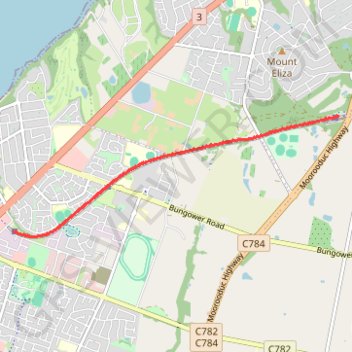
Mornington Tourist Railway
- Distance: 6.9 mi
- Elevation gain: 259 ft
- Maximum elevation: 197 ft
- Elevation loss: 259 ft
- Minimum elevation: 112 ft
- Moving time: 39 m 33 s
- Moving speed: 10.4 mph
- Maximum speed: 20.1 mph
- Total time: 1 h 1 m
- Global speed: 6.7 mph
Interactive trail map
Thank you for supporting this site ❤️
Make a donation
Make a donation
Gear up for your next adventure:
As an Amazon Associate, this site earns from qualifying purchases at no extra cost to you.
Trail profile
- Distance: 6.9 mi
- Elevation gain: 259 ft
- Maximum elevation: 197 ft
- Elevation loss: 259 ft
- Minimum elevation: 112 ft
- Moving time: 39 m 33 s
- Moving speed: 10.4 mph
- Maximum speed: 20.1 mph
- Total time: 1 h 1 m
- Global speed: 6.7 mph
Thank you for supporting this site ❤️
Make a donation
Make a donation
Gear up for your next adventure:
As an Amazon Associate, this site earns from qualifying purchases at no extra cost to you.
About this trail
Name: Mornington Tourist Railway trail, distance, elevation, map, profile, GPS track
Coordinates: -38.23059 145.05011 -38.21376 145.10759
Thank you for supporting this site ❤️
Make a donation
Make a donation
Gear up for your next adventure:
As an Amazon Associate, this site earns from qualifying purchases at no extra cost to you.
Other hiking, mountain biking, running and outdoor activity trails
Click on a trail to view its statistics, map and profile.