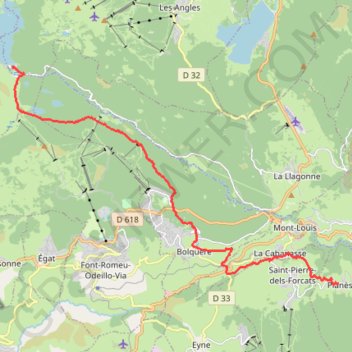
STAGE 46 Refuge des Bouillouses to Planes
- Distance: 11.8 mi
- Elevation gain: 2,477 ft
- Maximum elevation: 6,594 ft
- Elevation loss: 840 ft
- Minimum elevation: 4,836 ft
Interactive trail map
Trail profile
- Distance: 11.8 mi
- Elevation gain: 2,477 ft
- Maximum elevation: 6,594 ft
- Elevation loss: 840 ft
- Minimum elevation: 4,836 ft
About this trail
Name: STAGE 46 Refuge des Bouillouses to Planes trail, distance, elevation, map, profile, GPS track
Coordinates: 42.49181 2.00308 42.55925 2.13921
Other hiking, mountain biking, running and outdoor activity trails
Click on a trail to view its statistics, map and profile.
GR 10 - Traversée des Pyrénées
France > Occitania > Pyrénées-Orientales > Banyuls-sur-Mer
Distance: 543.6 mi • Elevation gain: 187,008 ft • Maximum elevation: 8,527 ft
1 LUCENA - MONTPELLIER
Distance: 1,842.0 mi • Elevation gain: 96,785 ft • Maximum elevation: 3,438 ft
Southern section — European Divide Trail
France > Auvergne-Rhône-Alpes > Drôme > Valence
Distance: 1,506.1 mi • Elevation gain: 139,026 ft • Maximum elevation: 6,578 ft