Thank you for supporting this site ❤️
Make a donation
Make a donation
Gear up for your next adventure:
As an Amazon Associate, this site earns from qualifying purchases at no extra cost to you.
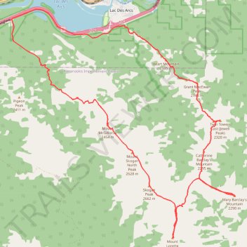
Heart Mountain, Grant McEwan Peak, Twin Towers, Catherine Barclay's Mountain, Mary Barclay's Mountain, Mount Lorette, Skogan Peak, Mount Skogan North Peak and Mount McGillivray Traverse
Loop hike in Bow Valley Wildland Provincial Park
- Distance: 20.0 mi
- Elevation gain: 9,111 ft
- Maximum elevation: 8,655 ft
- Elevation loss: 9,104 ft
- Minimum elevation: 4,239 ft
- Moving time: 15 h 3 m
- Moving speed: 1.3 mph
- Maximum speed: 6.3 mph
- Total time: 1 d 3 h
- Global speed: 0.7 mph
Interactive trail map
Thank you for supporting this site ❤️
Make a donation
Make a donation
Gear up for your next adventure:
As an Amazon Associate, this site earns from qualifying purchases at no extra cost to you.
Trail profile
- Distance: 20.0 mi
- Elevation gain: 9,111 ft
- Maximum elevation: 8,655 ft
- Elevation loss: 9,104 ft
- Minimum elevation: 4,239 ft
- Moving time: 15 h 3 m
- Moving speed: 1.3 mph
- Maximum speed: 6.3 mph
- Total time: 1 d 3 h
- Global speed: 0.7 mph
Thank you for supporting this site ❤️
Make a donation
Make a donation
Gear up for your next adventure:
As an Amazon Associate, this site earns from qualifying purchases at no extra cost to you.
About this trail
Name: Heart Mountain, Grant McEwan Peak, Twin Towers, Catherine Barclay's Mountain, Mary Barclay's Mountain, Mount Lorette, Skogan Peak, Mount Skogan North Peak and Mount McGillivray Traverse trail, distance, elevation, map, profile, GPS track
Coordinates: 50.98635 -115.21010 51.05482 -115.10370
Thank you for supporting this site ❤️
Make a donation
Make a donation
Gear up for your next adventure:
As an Amazon Associate, this site earns from qualifying purchases at no extra cost to you.