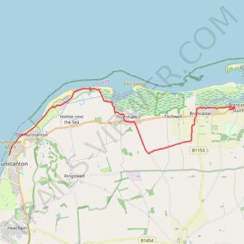
Norfolk Coast Path - Hunstanton to Brancaster Staithe
- Distance: 11.5 mi
- Elevation gain: 371 ft
- Maximum elevation: 187 ft
- Elevation loss: 374 ft
- Minimum elevation: 0 ft
- Moving time: 4 h 7 m
- Moving speed: 2.8 mph
- Maximum speed: 4.4 mph
- Total time: 4 h 42 m
- Global speed: 2.4 mph
Interactive trail map
Trail profile
- Distance: 11.5 mi
- Elevation gain: 371 ft
- Maximum elevation: 187 ft
- Elevation loss: 374 ft
- Minimum elevation: 0 ft
- Moving time: 4 h 7 m
- Moving speed: 2.8 mph
- Maximum speed: 4.4 mph
- Total time: 4 h 42 m
- Global speed: 2.4 mph
About this trail
Name: Norfolk Coast Path - Hunstanton to Brancaster Staithe trail, distance, elevation, map, profile, GPS track
Coordinates: 52.94334 0.48810 52.97534 0.66685