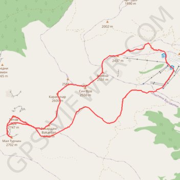
Šar Planina | Popova Šapka | Ceri - Pašin Vrh | Sinji Vrh | ...
- Distance: 15.4 mi
- Elevation gain: 5,217 ft
- Maximum elevation: 8,953 ft
- Elevation loss: 5,210 ft
- Minimum elevation: 5,581 ft
Interactive trail map
Trail profile
- Distance: 15.4 mi
- Elevation gain: 5,217 ft
- Maximum elevation: 8,953 ft
- Elevation loss: 5,210 ft
- Minimum elevation: 5,581 ft
About this trail
Name: Šar Planina | Popova Šapka | Ceri - Pašin Vrh | Sinji Vrh | ... trail, distance, elevation, map, profile, GPS track
Coordinates: 41.98366 20.79473 42.02084 20.88293
Other hiking, mountain biking, running and outdoor activity trails
Click on a trail to view its statistics, map and profile.
2022_Yu
Slovenia > Ajdovščina > Žapuže
Distance: 1,526.9 mi • Elevation gain: 105,144 ft • Maximum elevation: 6,398 ft