Poo-Poo Point via Chirico Trail in West Tiger Mountain Natural Resource Conservation Area
Hiking the Chirico Trail to Poo-Poo Point offers a delightful escape into nature, where the lush conifer forests gradually yield to breathtaking views. As you ascend, the trail's charm is accentuated by the steep stone steps, leading you through a landscape reminiscent of a classical painting, and culminating in panoramic vistas of Mount Rainier, Issaquah Alps and the Seattle skyline. At the top, you can enjoy the sight of paragliders gracefully launching into the sky while savoring a well-deserved snack at the viewpoint—making this a rewarding adventure for both seasoned hikers and families alike. #Hiking #Mountain #Forest #Nature
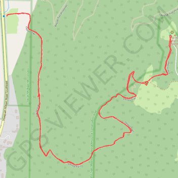
- Distance: 4.0 mi
- Elevation gain: 1,637 ft
- Maximum elevation: 1,791 ft
- Elevation loss: 1,637 ft
- Minimum elevation: 174 ft
- Moving time: 2 h 7 m
- Moving speed: 1.9 mph
- Maximum speed: 4.2 mph
- Total time: 2 h 23 m
- Global speed: 1.7 mph
Interactive trail map
Trail profile
- Distance: 4.0 mi
- Elevation gain: 1,637 ft
- Maximum elevation: 1,791 ft
- Elevation loss: 1,637 ft
- Minimum elevation: 174 ft
- Moving time: 2 h 7 m
- Moving speed: 1.9 mph
- Maximum speed: 4.2 mph
- Total time: 2 h 23 m
- Global speed: 1.7 mph
About this trail
Name: Poo-Poo Point via Chirico Trail in West Tiger Mountain Natural Resource Conservation Area trail, distance, elevation, map, profile, GPS track
Coordinates: 47.49217 -122.02199 47.50064 -122.00841
Topography: King County topographic map, elevation, terrain
Other hiking, mountain biking, running and outdoor activity trails
Click on a trail to view its statistics, map and profile.
Poo-Poo Point Trail
United States > Washington > King County > Issaquah
Starting near the Issaquah High School side of West Tiger Mountain, the trail enters a shaded forest and climbs steadily through the lower slopes of the natural resources conservation area. It then follows the wooded Poo Poo Point route, passing small creek draws and mossy woodland before reaching the open…
Distance: 6.9 mi • Elevation gain: 2,142 ft • Maximum elevation: 1,847 ft
Poo-Poo Point Trail in West Tiger Mountain Natural Resources Conservation Area
United States > Washington > King County > Issaquah
The Poo-Poo Point Trail in the West Tiger Mountain Natural Resources Conservation Area offers hikers a journey through lush, moss-covered forests, crossing picturesque streams via well-maintained bridges. Upon reaching Poo-Poo Point, you're rewarded with expansive views of the surrounding valleys, with the…
Distance: 6.8 mi • Elevation gain: 2,028 ft • Maximum elevation: 1,847 ft
Northern part of the Pacific Crest Trail (PCT)
United States > Oregon > Klamath County
Hike on the Pacific Crest National Scenic Trail from Crater Lake to Canada Border through Oregon and Washington along the Sierra Nevada and Cascade mountain ranges. #Hiking #Mountain #SierraNevada #Cascade #Nature #Forest #Park #PCT
Distance: 744.6 mi • Elevation gain: 145,367 ft • Maximum elevation: 7,569 ft
Poo Poo Point via High School Trail and Poo Poo Point Trail
United States > Washington > King County > Issaquah
Distance: 7.1 mi • Elevation gain: 2,083 ft • Maximum elevation: 1,847 ft
Poo Poo Point - Rescue Loop
United States > Washington > King County
Distance: 4.8 mi • Elevation gain: 2,149 ft • Maximum elevation: 1,821 ft
Poo Poo Point Rescue Trail
United States > Washington > King County
Distance: 4.4 mi • Elevation gain: 1,860 ft • Maximum elevation: 1,824 ft