Make a donation
Gear up for your next adventure:
As an Amazon Associate, this site earns from qualifying purchases at no extra cost to you.
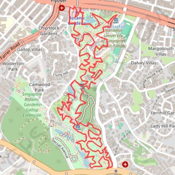
Singapore Botanical Gardens
- Distance: 6.6 mi
- Elevation gain: 528 ft
- Maximum elevation: 131 ft
- Elevation loss: 525 ft
- Minimum elevation: 13 ft
Interactive trail map
Make a donation
Gear up for your next adventure:
As an Amazon Associate, this site earns from qualifying purchases at no extra cost to you.
Trail profile
- Distance: 6.6 mi
- Elevation gain: 528 ft
- Maximum elevation: 131 ft
- Elevation loss: 525 ft
- Minimum elevation: 13 ft
Make a donation
Gear up for your next adventure:
As an Amazon Associate, this site earns from qualifying purchases at no extra cost to you.
About this trail
Name: Singapore Botanical Gardens trail, distance, elevation, map, profile, GPS track
Start: Cluny Road, Dalvey Villas, Tanglin, Central, Singapore, 258439, Singapore (1.31522 103.81704)
End: Cluny Road, Dalvey Villas, Tanglin, Central, Singapore, 258439, Singapore (1.31555 103.81687)
Coordinates: 1.30694 103.81332 1.32270 103.81912
Make a donation
Gear up for your next adventure:
As an Amazon Associate, this site earns from qualifying purchases at no extra cost to you.
Other hiking, mountain biking, running and outdoor activity trails
Click on a trail to view its statistics, map and profile.
Singapore Botanical Gardens.gpx
Distance: 6.6 mi • Elevation gain: 528 ft • Maximum elevation: 131 ft
The Green Corridor - Singapore
Distance: 13.8 mi • Elevation gain: 548 ft • Maximum elevation: 144 ft
Rail Corridor
Distance: 5.4 mi • Elevation gain: 364 ft • Maximum elevation: 174 ft
Directions from Duck Tour Ramp to Marina Boulevard, Singapore
Distance: 65.5 mi • Elevation gain: 2,664 ft • Maximum elevation: 167 ft
Make a donation
Gear up for your next adventure:
As an Amazon Associate, this site earns from qualifying purchases at no extra cost to you.
Singapore Botanical Gardens
Distance: 6.6 mi • Elevation gain: 528 ft • Maximum elevation: 131 ft