Import a GPX file

Kanarra Creek Canyon

Spring Creek Canyon Wilderness Study Area. #Hiking #Mountain #Forest #Nature

  • Distance: 6.2 mi
  • Elevation gain: 2,772 ft
  • Maximum elevation: 6,765 ft
  • Elevation loss: 2,772 ft
  • Minimum elevation: 5,627 ft

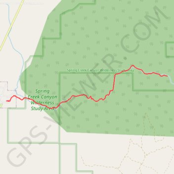
Interactive trail map

Trail profile

  • Distance: 6.2 mi
  • Elevation gain: 2,772 ft
  • Maximum elevation: 6,765 ft
  • Elevation loss: 2,772 ft
  • Minimum elevation: 5,627 ft

About this trail

Gear up for your next adventure:

🔌Solar Panel Charger - Charge gear sustainably outdoors
👟Men's Trail Runners - Lightweight footwear for fast-paced exploration and light hiking
🏫Relief Map Kits - Hands-on tools for teaching landforms and elevation
🥾Men's Hiking Boots - Durable, waterproof footwear for rugged terrain and steep inclines
🧭Compass with Lanyard - Easy‑carry compass for navigation

As an Amazon Associate, this site earns from qualifying purchases at no extra cost to you.