Thank you for supporting this site ❤️
Make a donation
Make a donation
Gear up for your next adventure:
As an Amazon Associate, this site earns from qualifying purchases at no extra cost to you.
Carburn Park Pond Loop
Interactive trail map
Thank you for supporting this site ❤️
Make a donation
Make a donation
Gear up for your next adventure:
As an Amazon Associate, this site earns from qualifying purchases at no extra cost to you.
Trail profile
- Distance: 1.4 mi
- Elevation gain: 39 ft
- Maximum elevation: 3,363 ft
- Elevation loss: 39 ft
- Minimum elevation: 3,340 ft
Thank you for supporting this site ❤️
Make a donation
Make a donation
Gear up for your next adventure:
As an Amazon Associate, this site earns from qualifying purchases at no extra cost to you.
About this trail
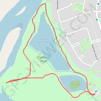
Name: Carburn Park Pond Loop trail, distance, elevation, map, profile, GPS track
Start: Carburn park connector, Riverbend, Calgary, Alberta, T2C 3R3, Canada (50.97358 -114.02616)
End: Carburn park connector, Riverbend, Calgary, Alberta, T2C 3R3, Canada (50.97356 -114.02616)
Coordinates: 50.97335 -114.03521 50.97934 -114.02616
Thank you for supporting this site ❤️
Make a donation
Make a donation
Gear up for your next adventure:
As an Amazon Associate, this site earns from qualifying purchases at no extra cost to you.