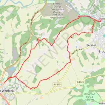
Much Wenlock to Ironbridge return
Circular walk all public foot paths
- Distance: 10.5 mi
- Elevation gain: 1,207 ft
- Maximum elevation: 761 ft
- Elevation loss: 1,207 ft
- Minimum elevation: 141 ft
- Moving time: 4 h 23 m
- Moving speed: 2.4 mph
- Maximum speed: 5.9 mph
- Total time: 5 h 59 m
- Global speed: 1.7 mph
Interactive trail map
Trail profile
- Distance: 10.5 mi
- Elevation gain: 1,207 ft
- Maximum elevation: 761 ft
- Elevation loss: 1,207 ft
- Minimum elevation: 141 ft
- Moving time: 4 h 23 m
- Moving speed: 2.4 mph
- Maximum speed: 5.9 mph
- Total time: 5 h 59 m
- Global speed: 1.7 mph
About this trail
Name: Much Wenlock to Ironbridge return trail, distance, elevation, map, profile, GPS track
Coordinates: 52.59629 -2.55741 52.62937 -2.48530