Thank you for supporting this site ❤️
Make a donation
Make a donation
Gear up for your next adventure:
As an Amazon Associate, this site earns from qualifying purchases at no extra cost to you.
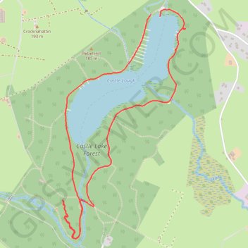
Castle Lake Walks
- Distance: 3.1 mi
- Elevation gain: 243 ft
- Maximum elevation: 522 ft
- Elevation loss: 253 ft
- Minimum elevation: 436 ft
- Moving time: 56 m 18 s
- Moving speed: 3.3 mph
- Maximum speed: 6.9 mph
- Total time: 1 h 8 m
- Global speed: 2.7 mph
Interactive trail map
Thank you for supporting this site ❤️
Make a donation
Make a donation
Gear up for your next adventure:
As an Amazon Associate, this site earns from qualifying purchases at no extra cost to you.
Trail profile
- Distance: 3.1 mi
- Elevation gain: 243 ft
- Maximum elevation: 522 ft
- Elevation loss: 253 ft
- Minimum elevation: 436 ft
- Moving time: 56 m 18 s
- Moving speed: 3.3 mph
- Maximum speed: 6.9 mph
- Total time: 1 h 8 m
- Global speed: 2.7 mph
Thank you for supporting this site ❤️
Make a donation
Make a donation
Gear up for your next adventure:
As an Amazon Associate, this site earns from qualifying purchases at no extra cost to you.
About this trail
Name: Castle Lake Walks trail, distance, elevation, map, profile, GPS track
Coordinates: 53.92573 -6.99108 53.93964 -6.97836
Thank you for supporting this site ❤️
Make a donation
Make a donation
Gear up for your next adventure:
As an Amazon Associate, this site earns from qualifying purchases at no extra cost to you.
Other hiking, mountain biking, running and outdoor activity trails
Click on a trail to view its statistics, map and profile.
Castle Lake Walks
Afternoon Run
Distance: 10.1 mi • Elevation gain: 971 ft • Maximum elevation: 587 ft
Castle Lake Walks
Afternoon Run
Distance: 7.5 mi • Elevation gain: 620 ft • Maximum elevation: 548 ft