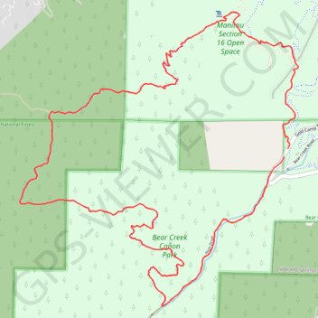
Section 16 Loop Trail via Palmer Red Rock Trail in Bear Creek Cañon Park
The Section 16 Loop Trail via the Palmer Red Rock Trail in Bear Creek Cañon Park offers hikers a diverse experience, beginning with exposed red rock formations that provide expansive views of the surrounding canyons and the Front Range peaks. As the trail ascends, it transitions into shaded ponderosa pine forests, offering a cooler environment and opportunities to observe local wildlife. The descent through Bear Creek Canyon concludes with the soothing sounds of the creek, enhancing the overall hiking experience. #Hiking #Mountain #Forest #Nature #Loop
- Distance: 5.9 mi
- Elevation gain: 1,499 ft
- Maximum elevation: 7,881 ft
- Elevation loss: 1,480 ft
- Minimum elevation: 6,634 ft
- Moving time: 2 h 6 m
- Moving speed: 2.8 mph
- Maximum speed: 5.3 mph
- Total time: 2 h 13 m
- Global speed: 2.7 mph
Interactive trail map
Trail profile
About this trail
Name: Section 16 Loop Trail via Palmer Red Rock Trail in Bear Creek Cañon Park trail, distance, elevation, map, profile, GPS track
Start: Gold Camp Road, El Paso County, Colorado, 80829, United States (38.82241 -104.89050)
End: Gold Camp Road, El Paso County, Colorado, 80829, United States (38.82184 -104.89086)
Coordinates: 38.81160 -104.91407 38.83178 -104.88956
Topography: El Paso County topographic map, elevation, terrain
Other hiking, mountain biking, running and outdoor activity trails
Click on a trail to view its statistics, map and profile.