Make a donation
Gear up for your next adventure:
As an Amazon Associate, this site earns from qualifying purchases at no extra cost to you.
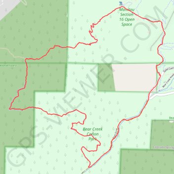
Palmer Loop (Section 16 Trail)
Interactive trail map
Make a donation
Gear up for your next adventure:
As an Amazon Associate, this site earns from qualifying purchases at no extra cost to you.
Trail profile
- Distance: 5.6 mi
- Elevation gain: 1,493 ft
- Maximum elevation: 7,871 ft
- Elevation loss: 1,493 ft
- Minimum elevation: 6,631 ft
Make a donation
Gear up for your next adventure:
As an Amazon Associate, this site earns from qualifying purchases at no extra cost to you.
About this trail
Name: Palmer Loop (Section 16 Trail) trail, distance, elevation, map, profile, GPS track
Start: Gold Camp Road, El Paso County, Colorado, 80829, United States (38.82182 -104.89079)
End: Gold Camp Road, El Paso County, Colorado, 80829, United States (38.82179 -104.89079)
Coordinates: 38.81165 -104.91395 38.83123 -104.88957
Topography: El Paso County topographic map, elevation, terrain
Make a donation
Gear up for your next adventure:
As an Amazon Associate, this site earns from qualifying purchases at no extra cost to you.
Other hiking, mountain biking, running and outdoor activity trails
Click on a trail to view its statistics, map and profile.
Section 16 Loop Trail via Palmer Red Rock Trail in Bear Creek Cañon Park
United States > Colorado > El Paso County
The Section 16 Loop Trail via the Palmer Red Rock Trail in Bear Creek Cañon Park offers hikers a diverse experience, beginning with exposed red rock formations that provide expansive views of the surrounding canyons and the Front Range peaks. As the trail ascends, it transitions into shaded ponderosa pine…
Distance: 5.9 mi • Elevation gain: 1,499 ft • Maximum elevation: 7,881 ft