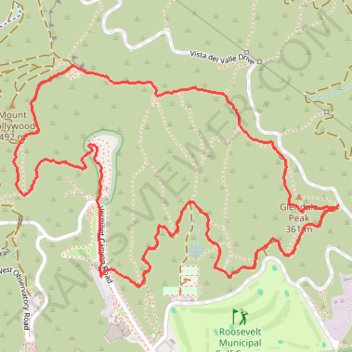
Glendale Peak and Mount Hollywood Loop via Riverside, Hogback, and Mount Hollywood Trails in Griffith Park
The Glendale Peak and Mount Hollywood Loop in Griffith Park offers hikers panoramic views of Los Angeles, including the Griffith Observatory, the Hollywood Sign, and the downtown skyline. The trail traverses diverse landscapes, from shaded paths to open ridges, providing a varied hiking experience. Along the way, you'll encounter landmarks such as the Greek Theatre and can enjoy vistas of the San Gabriel Mountains in the distance. #Hiking #Loop #Forest #Nature #Overlook
- Distance: 3.4 mi
- Elevation gain: 896 ft
- Maximum elevation: 1,503 ft
- Elevation loss: 896 ft
- Minimum elevation: 869 ft
- Moving time: 1 h 12 m
- Moving speed: 2.8 mph
- Maximum speed: 4.7 mph
- Total time: 1 h 15 m
- Global speed: 2.7 mph
Interactive trail map
Trail profile
- Distance: 3.4 mi
- Elevation gain: 896 ft
- Maximum elevation: 1,503 ft
- Elevation loss: 896 ft
- Minimum elevation: 869 ft
- Moving time: 1 h 12 m
- Moving speed: 2.8 mph
- Maximum speed: 4.7 mph
- Total time: 1 h 15 m
- Global speed: 2.7 mph
About this trail
Name: Glendale Peak and Mount Hollywood Loop via Riverside, Hogback, and Mount Hollywood Trails in Griffith Park trail, distance, elevation, map, profile, GPS track
Coordinates: 34.12121 -118.30110 34.12966 -118.28605
Topography: Los Angeles topographic map, elevation, terrain
Other hiking, mountain biking, running and outdoor activity trails
Click on a trail to view its statistics, map and profile.
Tom LaBonge Panorama via Bill Eckert Trail and North Trail in Griffith Park
United States > California > Los Angeles County > Los Angeles
This trail to Tom LaBonge Panorama offers a moderately challenging hike in Griffith Park, winding through scenic vistas with views of Mount Hollywood, Taco Peak, and the iconic Hollywood Sign. The trail provides a rewarding panoramic perspective of Los Angeles, including landmarks like the Griffith Park Old…
Distance: 6.2 mi • Elevation gain: 1,512 ft • Maximum elevation: 1,568 ft
Wonder View Trail
United States > California > Los Angeles County > Los Angeles
Hike from Lake Hollywood to Griffith Observatory via Burbank Peak Trail, Burbank Peak, Aileen Getty Ridge Trail, Cathuenga Peak, Hugh Hefner Overlook, Mount Lee, Hollywood Sign, Mount Lee Drive, Mulholland Trail, Mount Hollywood Drive and West Observatory Road in the Griffith Park. #Hiking #Hollywood #Nature…
Distance: 5.7 mi • Elevation gain: 1,621 ft • Maximum elevation: 1,729 ft