The Crinoline - Mount Tamboritha
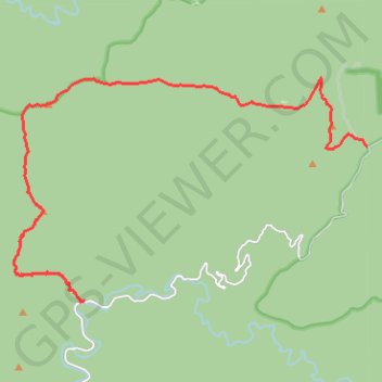
Interactive trail map
Trail profile
- Distance: 14.5 mi
- Elevation gain: 5,801 ft
- Maximum elevation: 4,931 ft
- Elevation loss: 2,631 ft
- Minimum elevation: 1,063 ft
About this trail
Name: The Crinoline - Mount Tamboritha trail, distance, elevation, map, profile, GPS track
Start: Crinoline Walking Track, Crookayan, Shire of Wellington, Victoria, Australia (-37.51762 146.61341)
End: Dingo Hill Track, Buragwonduc, Shire of Wellington, Victoria, Australia (-37.47701 146.70847)
Coordinates: -37.51788 146.59164 -37.45901 146.70847
Other hiking, mountain biking, running and outdoor activity trails
Click on a trail to view its statistics, map and profile.