Thank you for supporting this site ❤️
Make a donation
Make a donation
Gear up for your next adventure:
As an Amazon Associate, this site earns from qualifying purchases at no extra cost to you.
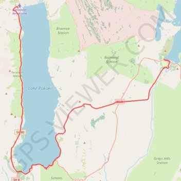
Lake Tekapo - Lake Pukaki - Glenntanner
#Bike
- Distance: 49.6 mi
- Elevation gain: 1,985 ft
- Maximum elevation: 2,464 ft
- Elevation loss: 2,507 ft
- Minimum elevation: 1,745 ft
Interactive trail map
Thank you for supporting this site ❤️
Make a donation
Make a donation
Gear up for your next adventure:
As an Amazon Associate, this site earns from qualifying purchases at no extra cost to you.
Trail profile
- Distance: 49.6 mi
- Elevation gain: 1,985 ft
- Maximum elevation: 2,464 ft
- Elevation loss: 2,507 ft
- Minimum elevation: 1,745 ft
Thank you for supporting this site ❤️
Make a donation
Make a donation
Gear up for your next adventure:
As an Amazon Associate, this site earns from qualifying purchases at no extra cost to you.
About this trail
Name: Lake Tekapo - Lake Pukaki - Glenntanner trail, distance, elevation, map, profile, GPS track
Coordinates: -44.19095 170.10816 -43.91216 170.47621
Thank you for supporting this site ❤️
Make a donation
Make a donation
Gear up for your next adventure:
As an Amazon Associate, this site earns from qualifying purchases at no extra cost to you.
Other hiking, mountain biking, running and outdoor activity trails
Click on a trail to view its statistics, map and profile.
Mount John Walkway loop via Mount John Observatory above Tekapo Lake
New Zealand > Canterbury > Mackenzie District > Lake Tekapo
Distance: 5.1 mi • Elevation gain: 1,243 ft • Maximum elevation: 3,304 ft