Thank you for supporting this site ❤️
Make a donation
Make a donation
Gear up for your next adventure:
As an Amazon Associate, this site earns from qualifying purchases at no extra cost to you.
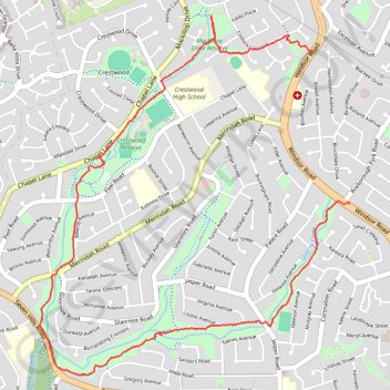
Sophia Doyle Reserve
#Hiking #Loop #SophiaDoyle #Sydney
- Distance: 4.2 mi
- Elevation gain: 171 ft
- Maximum elevation: 364 ft
- Elevation loss: 249 ft
- Minimum elevation: 167 ft
Interactive trail map
Thank you for supporting this site ❤️
Make a donation
Make a donation
Gear up for your next adventure:
As an Amazon Associate, this site earns from qualifying purchases at no extra cost to you.
Trail profile
- Distance: 4.2 mi
- Elevation gain: 171 ft
- Maximum elevation: 364 ft
- Elevation loss: 249 ft
- Minimum elevation: 167 ft
Thank you for supporting this site ❤️
Make a donation
Make a donation
Gear up for your next adventure:
As an Amazon Associate, this site earns from qualifying purchases at no extra cost to you.
About this trail
Name: Sophia Doyle Reserve trail, distance, elevation, map, profile, GPS track
Coordinates: -33.75999 150.96488 -33.73917 150.98641
Thank you for supporting this site ❤️
Make a donation
Make a donation
Gear up for your next adventure:
As an Amazon Associate, this site earns from qualifying purchases at no extra cost to you.
Other hiking, mountain biking, running and outdoor activity trails
Click on a trail to view its statistics, map and profile.