Make a donation
Gear up for your next adventure:
As an Amazon Associate, this site earns from qualifying purchases at no extra cost to you.
Burleigh Circuit
Interactive trail map
Make a donation
Gear up for your next adventure:
As an Amazon Associate, this site earns from qualifying purchases at no extra cost to you.
Trail profile
- Distance: 5.9 mi
- Elevation gain: 653 ft
- Maximum elevation: 233 ft
- Elevation loss: 653 ft
- Minimum elevation: -7 ft
Make a donation
Gear up for your next adventure:
As an Amazon Associate, this site earns from qualifying purchases at no extra cost to you.
About this trail
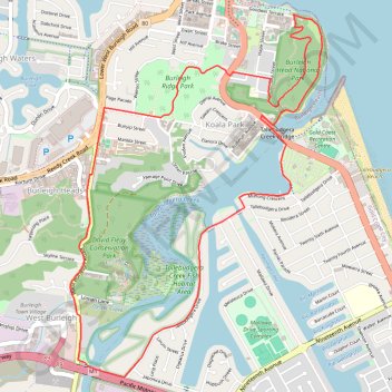
Name: Burleigh Circuit trail, distance, elevation, map, profile, GPS track
Coordinates: -28.11482 153.44077 -28.09023 153.46011
Make a donation
Gear up for your next adventure:
As an Amazon Associate, this site earns from qualifying purchases at no extra cost to you.
Other hiking, mountain biking, running and outdoor activity trails
Click on a trail to view its statistics, map and profile.
Burleigh Head National Park - Tumgun Lookout
Australia > Queensland > Gold Coast City
Distance: 2.0 mi • Elevation gain: 400 ft • Maximum elevation: 233 ft
Gold Coast - Coolangatta
Australia > Queensland > Gold Coast City
#Bike
Distance: 18.3 mi • Elevation gain: 643 ft • Maximum elevation: 92 ft