Make a donation
Gear up for your next adventure:
As an Amazon Associate, this site earns from qualifying purchases at no extra cost to you.
正坑秋楓東龍二輋沙頭左
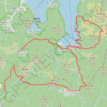
- Distance: 10.2 mi
- Elevation gain: 2,415 ft
- Maximum elevation: 948 ft
- Elevation loss: 1,985 ft
- Minimum elevation: 0 ft
- Moving time: 5 h 7 m
- Moving speed: 2.0 mph
- Maximum speed: 6.6 mph
- Total time: 8 h 6 m
- Global speed: 1.3 mph
Interactive trail map
Make a donation
Gear up for your next adventure:
As an Amazon Associate, this site earns from qualifying purchases at no extra cost to you.
Trail profile
- Distance: 10.2 mi
- Elevation gain: 2,415 ft
- Maximum elevation: 948 ft
- Elevation loss: 1,985 ft
- Minimum elevation: 0 ft
- Moving time: 5 h 7 m
- Moving speed: 2.0 mph
- Maximum speed: 6.6 mph
- Total time: 8 h 6 m
- Global speed: 1.3 mph
Make a donation
Gear up for your next adventure:
As an Amazon Associate, this site earns from qualifying purchases at no extra cost to you.
About this trail
Name: 正坑秋楓東龍二輋沙頭左 trail, distance, elevation, map, profile, GPS track
Start: Pak Tam Road, Tsak Yue Wu, Sai Kung District, New Territories, Hong Kong, China (22.40565 114.32526)
End: Pak Tam Road, Pak Tam Au, Tai Po District, New Territories, Hong Kong, China (22.42078 114.33199)
Coordinates: 22.40563 114.32526 22.43374 114.36479
Make a donation
Gear up for your next adventure:
As an Amazon Associate, this site earns from qualifying purchases at no extra cost to you.
Other hiking, mountain biking, running and outdoor activity trails
Click on a trail to view its statistics, map and profile.
石深右坑 石榕左坑 石榕坑 猴塘溪 土瓜坪坑
China > Hong Kong > Tai Po District > Lai Chi Chong
Hong Kong Hike
Distance: 8.2 mi • Elevation gain: 2,326 ft • Maximum elevation: 1,198 ft
城門~北潭坳
China > Hong Kong > Tsuen Wan District > Kwai Chung > Lower Shing Mun Village
ShingMunReservoir~PakTamAu
Distance: 23.3 mi • Elevation gain: 7,156 ft • Maximum elevation: 1,808 ft
田尾下源 橫頭墩北坑 田鹿石澗左 蛇地 秋楓
China > Hong Kong > Sai Kung District > Tsak Yue Wu
Distance: 13.1 mi • Elevation gain: 2,661 ft • Maximum elevation: 1,102 ft
鯽魚湖南坑 雷花石澗 坪輋西坑
China > Hong Kong > Sai Kung District
Hong Kong Hike
Distance: 6.9 mi • Elevation gain: 2,316 ft • Maximum elevation: 1,201 ft
Make a donation
Gear up for your next adventure:
As an Amazon Associate, this site earns from qualifying purchases at no extra cost to you.
蚺蛇尖山下
China > Hong Kong > Tai Po District > Pak Tam Au
Distance: 6.4 mi • Elevation gain: 1,473 ft • Maximum elevation: 778 ft
鯽魚湖西坑 蛇地坑 牌額西坑右源
China > Hong Kong > Sai Kung District > Tsak Yue Wu
Outdoor hiking
Distance: 7.0 mi • Elevation gain: 2,005 ft • Maximum elevation: 1,014 ft
東牛耳石坑 牛耳石坑 畫眉坑 雷榕石澗 畫眉西右坑 隱龍右源
China > Hong Kong > Tai Po District > Pak Tam Au
Hong Kong Hike
Distance: 8.4 mi • Elevation gain: 3,822 ft • Maximum elevation: 1,332 ft
Make a donation
Gear up for your next adventure:
As an Amazon Associate, this site earns from qualifying purchases at no extra cost to you.
西贡蚺蛇尖
China > Hong Kong > Tai Po District > Pak Tam Au
Distance: 8.4 mi • Elevation gain: 2,697 ft • Maximum elevation: 1,339 ft
麦理浩径
China > Hong Kong > Sai Kung District > Tsak Yue Wu
北潭涌至屯门
Distance: 61.3 mi • Elevation gain: 16,886 ft • Maximum elevation: 3,031 ft