Thank you for supporting this site ❤️
Make a donation
Make a donation
Gear up for your next adventure:
As an Amazon Associate, this site earns from qualifying purchases at no extra cost to you.
Shoshone Point
Interactive trail map
Thank you for supporting this site ❤️
Make a donation
Make a donation
Gear up for your next adventure:
As an Amazon Associate, this site earns from qualifying purchases at no extra cost to you.
Trail profile
- Distance: 1.0 mi
- Elevation gain: 85 ft
- Maximum elevation: 7,297 ft
- Elevation loss: 135 ft
- Minimum elevation: 7,169 ft
Thank you for supporting this site ❤️
Make a donation
Make a donation
Gear up for your next adventure:
As an Amazon Associate, this site earns from qualifying purchases at no extra cost to you.
About this trail
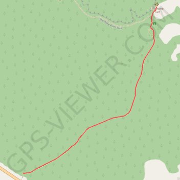
Name: Shoshone Point trail, distance, elevation, map, profile, GPS track
Start: East Rim Drive, Coconino County, Arizona, United States (36.03539 -112.06911)
End: Shoshone Point Trail, Coconino County, Arizona, United States (36.04556 -112.05901)
Coordinates: 36.03539 -112.06911 36.04556 -112.05901
Topography: Coconino County topographic map, elevation, terrain
Thank you for supporting this site ❤️
Make a donation
Make a donation
Gear up for your next adventure:
As an Amazon Associate, this site earns from qualifying purchases at no extra cost to you.