Make a donation
Gear up for your next adventure:
As an Amazon Associate, this site earns from qualifying purchases at no extra cost to you.
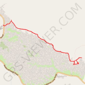
Castle Trail
Hike on the Castle Trail in the Badlands National Park. #Hiking #Desert #Nature #Park
- Distance: 4.9 mi
- Elevation gain: 144 ft
- Maximum elevation: 2,671 ft
- Elevation loss: 144 ft
- Minimum elevation: 2,608 ft
- Moving time: 2 h 13 m
- Moving speed: 2.2 mph
- Maximum speed: 3.7 mph
- Total time: 2 h 56 m
- Global speed: 1.7 mph
Interactive trail map
Make a donation
Gear up for your next adventure:
As an Amazon Associate, this site earns from qualifying purchases at no extra cost to you.
Trail profile
- Distance: 4.9 mi
- Elevation gain: 144 ft
- Maximum elevation: 2,671 ft
- Elevation loss: 144 ft
- Minimum elevation: 2,608 ft
- Moving time: 2 h 13 m
- Moving speed: 2.2 mph
- Maximum speed: 3.7 mph
- Total time: 2 h 56 m
- Global speed: 1.7 mph
Make a donation
Gear up for your next adventure:
As an Amazon Associate, this site earns from qualifying purchases at no extra cost to you.
About this trail
Name: Castle Trail trail, distance, elevation, map, profile, GPS track
Coordinates: 43.76104 -102.00294 43.77464 -101.96985
Topography: Jackson County topographic map, elevation, terrain
Make a donation
Gear up for your next adventure:
As an Amazon Associate, this site earns from qualifying purchases at no extra cost to you.
Other hiking, mountain biking, running and outdoor activity trails
Click on a trail to view its statistics, map and profile.
Castle Trail and Medicine Root Trail Loop in Badlands National Park
United States > South Dakota > Jackson County
This loop hike in Badlands National Park offers a good opportunity to explore the park’s unique landscape. The trail takes you through a striking mix of badland formations, mesas, and open prairies, expansive views along the way. Though the trail is exposed with little shade, the gentle terrain and varied…
Distance: 6.7 mi • Elevation gain: 194 ft • Maximum elevation: 2,657 ft