Thank you for supporting this site ❤️
Make a donation
Make a donation
Gear up for your next adventure:
As an Amazon Associate, this site earns from qualifying purchases at no extra cost to you.
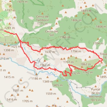
Trevenque
- Distance: 9.5 mi
- Elevation gain: 3,455 ft
- Maximum elevation: 6,762 ft
- Elevation loss: 3,205 ft
- Minimum elevation: 4,134 ft
Interactive trail map
Thank you for supporting this site ❤️
Make a donation
Make a donation
Gear up for your next adventure:
As an Amazon Associate, this site earns from qualifying purchases at no extra cost to you.
Trail profile
- Distance: 9.5 mi
- Elevation gain: 3,455 ft
- Maximum elevation: 6,762 ft
- Elevation loss: 3,205 ft
- Minimum elevation: 4,134 ft
Thank you for supporting this site ❤️
Make a donation
Make a donation
Gear up for your next adventure:
As an Amazon Associate, this site earns from qualifying purchases at no extra cost to you.
About this trail
Name: Trevenque trail, distance, elevation, map, profile, GPS track
Coordinates: 37.06662 -3.53310 37.08730 -3.47634
Thank you for supporting this site ❤️
Make a donation
Make a donation
Gear up for your next adventure:
As an Amazon Associate, this site earns from qualifying purchases at no extra cost to you.
Other hiking, mountain biking, running and outdoor activity trails
Click on a trail to view its statistics, map and profile.
Southern section — European Divide Trail
France > Auvergne-Rhône-Alpes > Drôme > Valence
Distance: 1,506.1 mi • Elevation gain: 139,026 ft • Maximum elevation: 6,578 ft