Make a donation
Gear up for your next adventure:
As an Amazon Associate, this site earns from qualifying purchases at no extra cost to you.
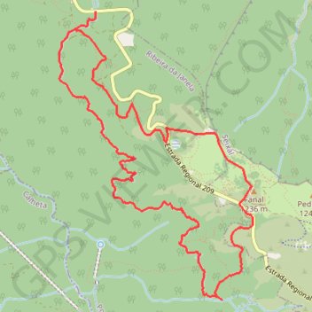
Madeira - PR 14 Levada dos Cedros - Steige unterhalb der ER ...
- Distance: 7.1 mi
- Elevation gain: 2,648 ft
- Maximum elevation: 3,799 ft
- Elevation loss: 2,648 ft
- Minimum elevation: 2,759 ft
- Moving time: 1 h 7 m
- Moving speed: 6.3 mph
- Maximum speed: 7.9 mph
- Total time: 1 h 7 m
- Global speed: 6.3 mph
Interactive trail map
Make a donation
Gear up for your next adventure:
As an Amazon Associate, this site earns from qualifying purchases at no extra cost to you.
Trail profile
- Distance: 7.1 mi
- Elevation gain: 2,648 ft
- Maximum elevation: 3,799 ft
- Elevation loss: 2,648 ft
- Minimum elevation: 2,759 ft
- Moving time: 1 h 7 m
- Moving speed: 6.3 mph
- Maximum speed: 7.9 mph
- Total time: 1 h 7 m
- Global speed: 6.3 mph
Make a donation
Gear up for your next adventure:
As an Amazon Associate, this site earns from qualifying purchases at no extra cost to you.
About this trail
Name: Madeira - PR 14 Levada dos Cedros - Steige unterhalb der ER ... trail, distance, elevation, map, profile, GPS track
Coordinates: 32.79936 -17.16191 32.82585 -17.14080
Make a donation
Gear up for your next adventure:
As an Amazon Associate, this site earns from qualifying purchases at no extra cost to you.
Other hiking, mountain biking, running and outdoor activity trails
Click on a trail to view its statistics, map and profile.
MIUT2020_115_training
Distance: 74.2 mi • Elevation gain: 33,179 ft • Maximum elevation: 5,896 ft
MIUT2023_115_training
Distance: 69.7 mi • Elevation gain: 30,787 ft • Maximum elevation: 5,896 ft
MIUT2020_115_training
Distance: 74.2 mi • Elevation gain: 33,179 ft • Maximum elevation: 5,896 ft