Make a donation
Gear up for your next adventure:
As an Amazon Associate, this site earns from qualifying purchases at no extra cost to you.
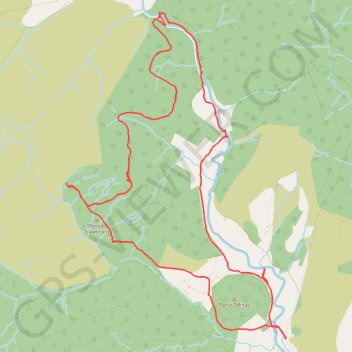
Irfon Forest
- Distance: 9.1 mi
- Elevation gain: 1,496 ft
- Maximum elevation: 1,575 ft
- Elevation loss: 1,499 ft
- Minimum elevation: 705 ft
- Moving time: 4 h 7 m
- Moving speed: 2.2 mph
- Maximum speed: 3.5 mph
- Total time: 5 h 50 m
- Global speed: 1.6 mph
Interactive trail map
Make a donation
Gear up for your next adventure:
As an Amazon Associate, this site earns from qualifying purchases at no extra cost to you.
Trail profile
- Distance: 9.1 mi
- Elevation gain: 1,496 ft
- Maximum elevation: 1,575 ft
- Elevation loss: 1,499 ft
- Minimum elevation: 705 ft
- Moving time: 4 h 7 m
- Moving speed: 2.2 mph
- Maximum speed: 3.5 mph
- Total time: 5 h 50 m
- Global speed: 1.6 mph
Make a donation
Gear up for your next adventure:
As an Amazon Associate, this site earns from qualifying purchases at no extra cost to you.
About this trail
Name: Irfon Forest trail, distance, elevation, map, profile, GPS track
Start: Llanwrtyd Wells, Powys, Wales, LD5 4SY, United Kingdom (52.11526 -3.65821)
End: Llanwrtyd Wells, Powys, Wales, LD5 4SY, United Kingdom (52.11521 -3.65820)
Coordinates: 52.11514 -3.69530 52.14897 -3.65797
Make a donation
Gear up for your next adventure:
As an Amazon Associate, this site earns from qualifying purchases at no extra cost to you.
Other hiking, mountain biking, running and outdoor activity trails
Click on a trail to view its statistics, map and profile.
The Headstock 500
United Kingdom > Wales > Newport > Newport
Distance: 300.4 mi • Elevation gain: 31,549 ft • Maximum elevation: 2,267 ft
Nant Gwyn
United Kingdom > Wales > Powys > Llanwrtyd Wells
Distance: 7.2 mi • Elevation gain: 1,299 ft • Maximum elevation: 1,440 ft