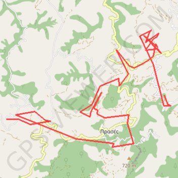
Thank you for supporting this site ❤️
Make a donation
Make a donation
Gear up for your next adventure:
As an Amazon Associate, this site earns from qualifying purchases at no extra cost to you.
Simeia_03-IOUL-24
- Distance: 14.7 mi
- Elevation gain: 2,723 ft
- Maximum elevation: 2,251 ft
- Elevation loss: 2,831 ft
- Minimum elevation: 1,040 ft
- Moving time: 2 h 3 m
- Moving speed: 7.2 mph
- Maximum speed: 16.5 mph
- Total time: 2 h 3 m
- Global speed: 7.2 mph
Interactive trail map
Thank you for supporting this site ❤️
Make a donation
Make a donation
Gear up for your next adventure:
As an Amazon Associate, this site earns from qualifying purchases at no extra cost to you.
Trail profile
- Distance: 14.7 mi
- Elevation gain: 2,723 ft
- Maximum elevation: 2,251 ft
- Elevation loss: 2,831 ft
- Minimum elevation: 1,040 ft
- Moving time: 2 h 3 m
- Moving speed: 7.2 mph
- Maximum speed: 16.5 mph
- Total time: 2 h 3 m
- Global speed: 7.2 mph
Thank you for supporting this site ❤️
Make a donation
Make a donation
Gear up for your next adventure:
As an Amazon Associate, this site earns from qualifying purchases at no extra cost to you.
About this trail
Name: Simeia_03-IOUL-24 trail, distance, elevation, map, profile, GPS track
Coordinates: 35.37183 23.81157 35.40587 23.87046
Thank you for supporting this site ❤️
Make a donation
Make a donation
Gear up for your next adventure:
As an Amazon Associate, this site earns from qualifying purchases at no extra cost to you.