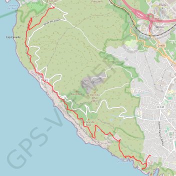
De la Ciotat à Cassis par les crêtes
- Distance: 6.3 mi
- Elevation gain: 3,284 ft
- Maximum elevation: 1,240 ft
- Elevation loss: 2,720 ft
- Minimum elevation: 112 ft
Interactive trail map
Trail profile
- Distance: 6.3 mi
- Elevation gain: 3,284 ft
- Maximum elevation: 1,240 ft
- Elevation loss: 2,720 ft
- Minimum elevation: 112 ft
About this trail
Name: De la Ciotat à Cassis par les crêtes trail, distance, elevation, map, profile, GPS track
Coordinates: 43.16653 5.55178 43.20692 5.59465
Other hiking, mountain biking, running and outdoor activity trails
Click on a trail to view its statistics, map and profile.
1 LUCENA - MONTPELLIER
Distance: 1,842.0 mi • Elevation gain: 96,785 ft • Maximum elevation: 3,438 ft
PT23DS2 Lörrach → Cadaqués
Germany > Baden-Württemberg > Landkreis Lörrach > Lörrach (Kernstadt)
Distance: 652.9 mi • Elevation gain: 43,077 ft • Maximum elevation: 4,938 ft
Chemin de Saint-Jacques-de-Compostelle
Switzerland > Geneva > Geneva
Distance: 694.6 mi • Elevation gain: 82,881 ft • Maximum elevation: 4,692 ft