Thank you for supporting this site ❤️
Make a donation
Make a donation
Gear up for your next adventure:
As an Amazon Associate, this site earns from qualifying purchases at no extra cost to you.
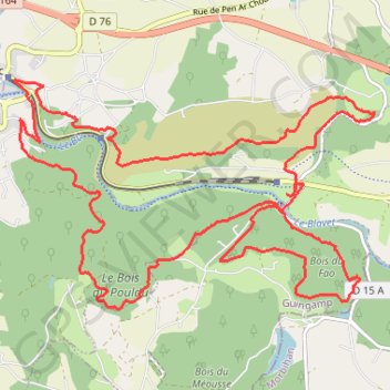
Trail de Guerlédan
- Distance: 14.4 mi
- Elevation gain: 2,526 ft
- Maximum elevation: 889 ft
- Elevation loss: 2,526 ft
- Minimum elevation: 410 ft
Interactive trail map
Thank you for supporting this site ❤️
Make a donation
Make a donation
Gear up for your next adventure:
As an Amazon Associate, this site earns from qualifying purchases at no extra cost to you.
Trail profile
- Distance: 14.4 mi
- Elevation gain: 2,526 ft
- Maximum elevation: 889 ft
- Elevation loss: 2,526 ft
- Minimum elevation: 410 ft
Thank you for supporting this site ❤️
Make a donation
Make a donation
Gear up for your next adventure:
As an Amazon Associate, this site earns from qualifying purchases at no extra cost to you.
About this trail
Name: Trail de Guerlédan trail, distance, elevation, map, profile, GPS track
Coordinates: 48.20077 -3.17487 48.22632 -3.11475
Thank you for supporting this site ❤️
Make a donation
Make a donation
Gear up for your next adventure:
As an Amazon Associate, this site earns from qualifying purchases at no extra cost to you.