Thank you for supporting this site ❤️
Make a donation
Make a donation
Gear up for your next adventure:
As an Amazon Associate, this site earns from qualifying purchases at no extra cost to you.
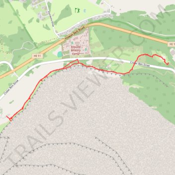
Crater Rim Trail and Sulphur Banks Trail
- Distance: 4.3 mi
- Elevation gain: 1,109 ft
- Maximum elevation: 4,032 ft
- Elevation loss: 1,017 ft
- Minimum elevation: 3,780 ft
- Moving time: 1 h 36 m
- Moving speed: 2.7 mph
- Maximum speed: 5.5 mph
- Total time: 2 h 24 s
- Global speed: 2.2 mph
Interactive trail map
Thank you for supporting this site ❤️
Make a donation
Make a donation
Gear up for your next adventure:
As an Amazon Associate, this site earns from qualifying purchases at no extra cost to you.
Trail profile
- Distance: 4.3 mi
- Elevation gain: 1,109 ft
- Maximum elevation: 4,032 ft
- Elevation loss: 1,017 ft
- Minimum elevation: 3,780 ft
- Moving time: 1 h 36 m
- Moving speed: 2.7 mph
- Maximum speed: 5.5 mph
- Total time: 2 h 24 s
- Global speed: 2.2 mph
Thank you for supporting this site ❤️
Make a donation
Make a donation
Gear up for your next adventure:
As an Amazon Associate, this site earns from qualifying purchases at no extra cost to you.
About this trail
Name: Crater Rim Trail and Sulphur Banks Trail trail, distance, elevation, map, profile, GPS track
Coordinates: 19.42319 -155.28470 19.43265 -155.26033
Topography: Hawaiʻi County topographic map, elevation, terrain
Thank you for supporting this site ❤️
Make a donation
Make a donation
Gear up for your next adventure:
As an Amazon Associate, this site earns from qualifying purchases at no extra cost to you.