Thank you for supporting this site ❤️
Make a donation
Make a donation
Gear up for your next adventure:
As an Amazon Associate, this site earns from qualifying purchases at no extra cost to you.
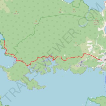
North Arm to Oban
- Distance: 7.8 mi
- Elevation gain: 1,047 ft
- Maximum elevation: 331 ft
- Elevation loss: 1,099 ft
- Minimum elevation: 0 ft
- Moving time: 3 h 19 m
- Moving speed: 2.4 mph
- Maximum speed: 3.6 mph
- Total time: 3 h 43 m
- Global speed: 2.1 mph
Interactive trail map
Thank you for supporting this site ❤️
Make a donation
Make a donation
Gear up for your next adventure:
As an Amazon Associate, this site earns from qualifying purchases at no extra cost to you.
Trail profile
- Distance: 7.8 mi
- Elevation gain: 1,047 ft
- Maximum elevation: 331 ft
- Elevation loss: 1,099 ft
- Minimum elevation: 0 ft
- Moving time: 3 h 19 m
- Moving speed: 2.4 mph
- Maximum speed: 3.6 mph
- Total time: 3 h 43 m
- Global speed: 2.1 mph
Thank you for supporting this site ❤️
Make a donation
Make a donation
Gear up for your next adventure:
As an Amazon Associate, this site earns from qualifying purchases at no extra cost to you.
About this trail
Name: North Arm to Oban trail, distance, elevation, map, profile, GPS track
Coordinates: -46.90236 168.01861 -46.88384 168.12404
Thank you for supporting this site ❤️
Make a donation
Make a donation
Gear up for your next adventure:
As an Amazon Associate, this site earns from qualifying purchases at no extra cost to you.
Other hiking, mountain biking, running and outdoor activity trails
Click on a trail to view its statistics, map and profile.
Port William to North Arm
New Zealand > Southland > Southland District > Stewart Island / Rakiura Community
Distance: 7.8 mi • Elevation gain: 1,394 ft • Maximum elevation: 594 ft