
Cape Falcon Trail in Oswald West State Park
The Cape Falcon Trail in Oswald West State Park offers hikers a journey through lush old-growth forests, leading to a headland with panoramic views of the Pacific Ocean, with sights extending southward to Neahkahnie Mountain. Along the way, the trail provides glimpses of Short Sand Beach, a popular spot for surfers nestled between coastal cliffs. The path is lined with towering Sitka spruce and western hemlock trees, creating a serene atmosphere characteristic of the Pacific Northwest. #Hiking #Coast #Forest #Nature #Sea #Pacific #Ocean #Beach
- Distance: 4.5 mi
- Elevation gain: 1,109 ft
- Maximum elevation: 328 ft
- Elevation loss: 1,109 ft
- Minimum elevation: 23 ft
- Moving time: 1 h 57 m
- Moving speed: 2.3 mph
- Maximum speed: 4.2 mph
- Total time: 2 h 41 m
- Global speed: 1.7 mph
Interactive trail map
Trail profile
- Distance: 4.5 mi
- Elevation gain: 1,109 ft
- Maximum elevation: 328 ft
- Elevation loss: 1,109 ft
- Minimum elevation: 23 ft
- Moving time: 1 h 57 m
- Moving speed: 2.3 mph
- Maximum speed: 4.2 mph
- Total time: 2 h 41 m
- Global speed: 1.7 mph
About this trail
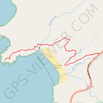
Name: Cape Falcon Trail in Oswald West State Park trail, distance, elevation, map, profile, GPS track
Start: Upper Short Sand Creek Trail, Tillamook County, Oregon, 97102, United States (45.76298 -123.95627)
End: Cape Falcon Trail, Tillamook County, Oregon, 97102, United States (45.76297 -123.95630)
Coordinates: 45.76085 -123.98143 45.76613 -123.95606
Topography: Tillamook County topographic map, elevation, terrain