Woodstock Nature Reserve
- Distance: 4.6 mi
- Elevation gain: 869 ft
- Maximum elevation: 1,929 ft
- Elevation loss: 804 ft
- Minimum elevation: 1,480 ft
- Moving time: 2 h 53 m
- Moving speed: 1.6 mph
- Maximum speed: 4.7 mph
- Total time: 3 h 15 m
- Global speed: 1.4 mph
Interactive trail map
Trail profile
- Distance: 4.6 mi
- Elevation gain: 869 ft
- Maximum elevation: 1,929 ft
- Elevation loss: 804 ft
- Minimum elevation: 1,480 ft
- Moving time: 2 h 53 m
- Moving speed: 1.6 mph
- Maximum speed: 4.7 mph
- Total time: 3 h 15 m
- Global speed: 1.4 mph
About this trail
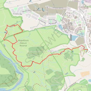
Name: Woodstock Nature Reserve trail, distance, elevation, map, profile, GPS track
Coordinates: -35.23612 148.97097 -35.22609 148.99572
Other hiking, mountain biking, running and outdoor activity trails
Click on a trail to view its statistics, map and profile.
Shepherds Lookout Loop within The Corridor at Strathnairn
Australia > District of Belconnen
Distance: 6.3 mi • Elevation gain: 1,079 ft • Maximum elevation: 1,965 ft
The Nguurung Bila Loop, the Woodland Loop, and the River Decent Tracks within The Corridor at Strathnairn walked
Australia > District of Belconnen
Distance: 7.5 mi • Elevation gain: 1,289 ft • Maximum elevation: 1,939 ft
Cloudride24.FINAL
Distance: 639.3 mi • Elevation gain: 69,823 ft • Maximum elevation: 5,755 ft