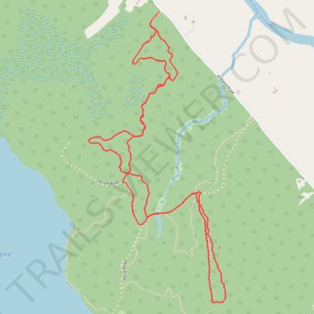
Swans trails
- Distance: 4.7 mi
- Elevation gain: 217 ft
- Maximum elevation: 197 ft
- Elevation loss: 210 ft
- Minimum elevation: 121 ft
- Moving time: 2 h 8 m
- Moving speed: 2.2 mph
- Maximum speed: 3.6 mph
- Total time: 3 h 27 m
- Global speed: 1.4 mph
Interactive trail map
Trail profile
- Distance: 4.7 mi
- Elevation gain: 217 ft
- Maximum elevation: 197 ft
- Elevation loss: 210 ft
- Minimum elevation: 121 ft
- Moving time: 2 h 8 m
- Moving speed: 2.2 mph
- Maximum speed: 3.6 mph
- Total time: 3 h 27 m
- Global speed: 1.4 mph
About this trail
Name: Swans trails trail, distance, elevation, map, profile, GPS track
Start: Kirkland Road, West Old Town, Old Town, Penobscot County, Maine, United States (44.96692 -68.76570)
Coordinates: 44.94845 -68.77145 44.96751 -68.75876
Topography: Penobscot County topographic map, elevation, terrain