Thank you for supporting this site ❤️
Make a donation
Make a donation
Gear up for your next adventure:
As an Amazon Associate, this site earns from qualifying purchases at no extra cost to you.
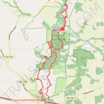
The Tuckahoe 25k
- Distance: 14.6 mi
- Elevation gain: 512 ft
- Maximum elevation: 59 ft
- Elevation loss: 515 ft
- Minimum elevation: 10 ft
- Moving time: 2 h 16 m
- Moving speed: 6.4 mph
- Maximum speed: 10.6 mph
- Total time: 2 h 16 m
- Global speed: 6.4 mph
Interactive trail map
Thank you for supporting this site ❤️
Make a donation
Make a donation
Gear up for your next adventure:
As an Amazon Associate, this site earns from qualifying purchases at no extra cost to you.
Trail profile
- Distance: 14.6 mi
- Elevation gain: 512 ft
- Maximum elevation: 59 ft
- Elevation loss: 515 ft
- Minimum elevation: 10 ft
- Moving time: 2 h 16 m
- Moving speed: 6.4 mph
- Maximum speed: 10.6 mph
- Total time: 2 h 16 m
- Global speed: 6.4 mph
Thank you for supporting this site ❤️
Make a donation
Make a donation
Gear up for your next adventure:
As an Amazon Associate, this site earns from qualifying purchases at no extra cost to you.
About this trail
Name: The Tuckahoe 25k trail, distance, elevation, map, profile, GPS track
Start: Caroline County, Maryland, 21641, United States (38.97558 -75.93334)
End: Caroline County, Maryland, 21641, United States (38.97571 -75.93353)
Coordinates: 38.92358 -75.95706 38.98362 -75.93209
Topography: Caroline County topographic map, elevation, terrain
Thank you for supporting this site ❤️
Make a donation
Make a donation
Gear up for your next adventure:
As an Amazon Associate, this site earns from qualifying purchases at no extra cost to you.