Make a donation
Gear up for your next adventure:
As an Amazon Associate, this site earns from qualifying purchases at no extra cost to you.
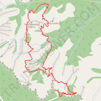
Peekaboo Loop Trail
Interactive trail map
Make a donation
Gear up for your next adventure:
As an Amazon Associate, this site earns from qualifying purchases at no extra cost to you.
Trail profile
- Distance: 4.9 mi
- Elevation gain: 1,572 ft
- Maximum elevation: 8,317 ft
- Elevation loss: 1,575 ft
- Minimum elevation: 7,451 ft
- Moving time: 2 h 4 m
- Moving speed: 2.4 mph
- Maximum speed: 4.9 mph
- Total time: 2 h 11 m
- Global speed: 2.2 mph
Make a donation
Gear up for your next adventure:
As an Amazon Associate, this site earns from qualifying purchases at no extra cost to you.
About this trail
Name: Peekaboo Loop Trail trail, distance, elevation, map, profile, GPS track
Start: Rim Trail, Garfield County, Utah, United States (37.60435 -112.15689)
End: Under-the-Rim Trail, Garfield County, Utah, United States (37.60435 -112.15682)
Coordinates: 37.60335 -112.16284 37.61759 -112.15287
Topography: Garfield County topographic map, elevation, terrain
Make a donation
Gear up for your next adventure:
As an Amazon Associate, this site earns from qualifying purchases at no extra cost to you.
Other hiking, mountain biking, running and outdoor activity trails
Click on a trail to view its statistics, map and profile.
Figure-8 Combination Loop (Bryce Canyon)
United States > Utah > Garfield County
From Sunset Point, the route first follows the rim toward Sunrise Point, opening broad views over the Bryce Amphitheater before dropping into Queen’s Garden, where pale orange hoodoos, sculpted walls, and fir-dotted slopes gradually surround the trail. The descent leads from the overlook atmosphere of the…
Distance: 6.4 mi • Elevation gain: 1,640 ft • Maximum elevation: 7,976 ft
Peekaboo Loop Trail in Bryce Canyon National Park
United States > Utah > Garfield County
The Peekaboo Loop Trail in Bryce Canyon National Park offers hikers an immersive journey through a landscape adorned with towering red and orange hoodoos. As you navigate the trail, you'll encounter notable formations such as the Wall of Windows, the Cathedral, Hindu Temples, Fairy Castle and Peek-a-Boo Arch…
Distance: 5.0 mi • Elevation gain: 1,585 ft • Maximum elevation: 8,320 ft
Navajo Loop Trail and Peekaboo Loop Trail in Bryce Canyon National Park
United States > Utah > Garfield County
The combined Navajo Loop and Peekaboo Loop trails in Bryce Canyon National Park offer hikers an immersive journey through the park's iconic red rock formations. The Navajo Loop takes hikers through narrow passages between towering hoodoos, with stunning views of the park's signature rock formations such as the…
Distance: 5.3 mi • Elevation gain: 1,568 ft • Maximum elevation: 8,009 ft
Make a donation
Gear up for your next adventure:
As an Amazon Associate, this site earns from qualifying purchases at no extra cost to you.
Bryce Canyon National Park Peek-a-Boo Loop
United States > Utah > Garfield County
BCNP
Distance: 15.9 mi • Elevation gain: 2,740 ft • Maximum elevation: 8,330 ft