Spooky Slot Canyon and Peek-A-Boo Slot Canyon Loop Trail
The Peek-A-Boo and Spooky Slot Canyons Loop Trail offers a fascinating, though physically challenging, hiking experience in the Grand Staircase-Escalante National Monument. Hikers are treated to dramatic, narrow passages through the slot canyons, with Peek-A-Boo presenting impressive rock formations and a rewarding climb to access the canyon, while Spooky is known for its tight squeezes that require crawling or shimmying between the canyon walls. The terrain includes rocky and sandy washes, often with cairns marking the way, and the route requires scrambling and careful navigation, especially in the tightest sections. This hike offers a unique and exhilarating adventure for those comfortable with mild rock climbing and navigating claustrophobic spaces. #Hiking #Canyon #Rock #Nature #Desert
- Distance: 2.9 mi
- Elevation gain: 512 ft
- Maximum elevation: 4,961 ft
- Elevation loss: 512 ft
- Minimum elevation: 4,665 ft
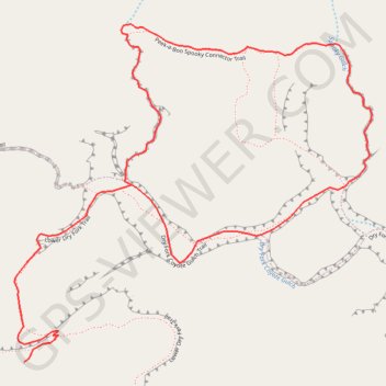
Interactive trail map
Trail profile
- Distance: 2.9 mi
- Elevation gain: 512 ft
- Maximum elevation: 4,961 ft
- Elevation loss: 512 ft
- Minimum elevation: 4,665 ft
About this trail
Name: Spooky Slot Canyon and Peek-A-Boo Slot Canyon Loop Trail trail, distance, elevation, map, profile, GPS track
Start: Lower Dry Fork Trail, Kane County, Utah, United States (37.47676 -111.22007)
End: Lower Dry Fork Trail, Kane County, Utah, United States (37.47676 -111.22007)
Coordinates: 37.47676 -111.22039 37.48577 -111.20837
Topography: Kane County topographic map, elevation, terrain
Other hiking, mountain biking, running and outdoor activity trails
Click on a trail to view its statistics, map and profile.
Dry Fork Narrows, Peek-A-Boo and Spooky Slot Canyons Loop
United States > Utah > Kane County
From the Dry Fork trailhead near Hole-in-the-Rock Road, the route crosses open slickrock and sandy desert benches before dropping into Dry Fork of Coyote Gulch, where the broad wash leads toward the smooth, shadowed corridors of Dry Fork Narrows. This Scorpion Wilderness Study Area hike sits within Grand…
Distance: 6.1 mi • Elevation gain: 728 ft • Maximum elevation: 4,977 ft
Peek-a-Boo Slot Canyon, Spooky Slot Canyon and Dry Fork Narrows Loop
United States > Utah > Kane County
Loop hike via Lower Dry Fork Trail, Peek-a-Boo Slot Canyon, Spooky Slot Canyon, Dry Fork Coyote Gulch Trail and Dry Fork Narrows Trail in the Scorpion Wilderness Study Area and the Grand Staircase-Escalante National Monument. #Hiking #Loop #Canyon #Nature #Wilderness
Distance: 3.7 mi • Elevation gain: 548 ft • Maximum elevation: 4,961 ft