Lake Twentytwo Loop in Mount Baker-Snoqualmie National Forest
The Lake Twentytwo Loop offers a picturesque hiking experience that immerses you in the lush, moss-draped forests typical of the Pacific Northwest. The trail leads through dense old-growth forests, crossing streams and small waterfalls, before opening to rocky fields where the surrounding peaks, including Mount Pilchuck, come into view. Upon reaching the lake, hikers are treated to stunning reflections of towering cliffs and numerous waterfalls in the calm waters, making this a memorable destination for nature lovers and photography enthusiasts. #Hiking #Mountain #Forest #Nature #Lake #Loop
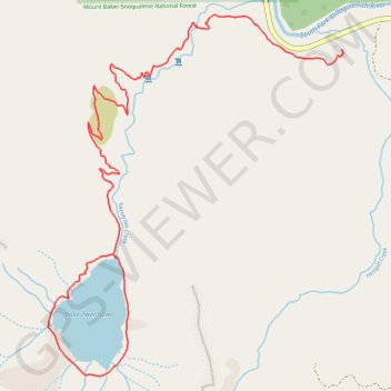
- Distance: 6.0 mi
- Elevation gain: 1,686 ft
- Maximum elevation: 2,490 ft
- Elevation loss: 1,683 ft
- Minimum elevation: 1,125 ft
Interactive trail map
Trail profile
- Distance: 6.0 mi
- Elevation gain: 1,686 ft
- Maximum elevation: 2,490 ft
- Elevation loss: 1,683 ft
- Minimum elevation: 1,125 ft
About this trail
Name: Lake Twentytwo Loop in Mount Baker-Snoqualmie National Forest trail, distance, elevation, map, profile, GPS track
Coordinates: 48.06104 -121.76726 48.07887 -121.74551
Topography: Snohomish County topographic map, elevation, terrain
Other hiking, mountain biking, running and outdoor activity trails
Click on a trail to view its statistics, map and profile.
Lake Twentytwo Loop
United States > Washington > Snohomish County > Verlot
Distance: 5.8 mi • Elevation gain: 1,444 ft • Maximum elevation: 2,493 ft
Northern part of the Pacific Crest Trail (PCT)
United States > Oregon > Klamath County
Hike on the Pacific Crest National Scenic Trail from Crater Lake to Canada Border through Oregon and Washington along the Sierra Nevada and Cascade mountain ranges. #Hiking #Mountain #SierraNevada #Cascade #Nature #Forest #Park #PCT
Distance: 744.6 mi • Elevation gain: 145,367 ft • Maximum elevation: 7,569 ft