Mount Yonah Trail in Chattahoochee-Oconee National Forest
The Mount Yonah Trail presents a rewarding hike for those prepared for a challenge. As you ascend through lush forests of hardwoods and pines, you’ll encounter rocky outcroppings and steep sections, with the ultimate payoff being breathtaking panoramic views from the summit. From here, hikers can enjoy sweeping vistas of the Blue Ridge Mountains, Lake Chatuge, and Brasstown Bald, making it a top destination for both seasoned hikers and rock climbers. #Hiking #Mountain #Overlook #Forest #Nature
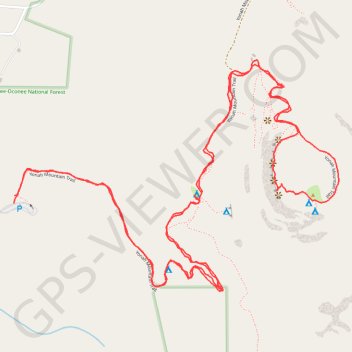
- Distance: 4.5 mi
- Elevation gain: 1,565 ft
- Maximum elevation: 3,120 ft
- Elevation loss: 1,575 ft
- Minimum elevation: 1,736 ft
- Moving time: 2 h 58 m
- Moving speed: 1.5 mph
- Maximum speed: 3.4 mph
- Total time: 3 h 18 m
- Global speed: 1.4 mph
Interactive trail map
Trail profile
- Distance: 4.5 mi
- Elevation gain: 1,565 ft
- Maximum elevation: 3,120 ft
- Elevation loss: 1,575 ft
- Minimum elevation: 1,736 ft
- Moving time: 2 h 58 m
- Moving speed: 1.5 mph
- Maximum speed: 3.4 mph
- Total time: 3 h 18 m
- Global speed: 1.4 mph
About this trail
Name: Mount Yonah Trail in Chattahoochee-Oconee National Forest trail, distance, elevation, map, profile, GPS track
Start: Yonah Mountain Trail, White County, Georgia, United States (34.63759 -83.72561)
End: Yonah Mountain Trail, White County, Georgia, United States (34.63733 -83.72563)
Coordinates: 34.63431 -83.72567 34.64218 -83.71227
Topography: White County topographic map, elevation, terrain
Other hiking, mountain biking, running and outdoor activity trails
Click on a trail to view its statistics, map and profile.