Natural Bridge Trail, Laurel Bridge Trail and Battleship Rock Trail Loop
This loop in Kentucky’s Natural Bridge State Resort Park takes hikers through a vibrant forest landscape, leading to sweeping cliffside views and impressive sandstone formations. Notable highlights include the breathtaking view from atop the Natural Bridge and the thrilling descent through narrow rock passages like “Fat Man’s Squeeze” and the steep, scenic steps of Devil’s Gulch. Battleship Rock offers additional panoramic views, making this route a perfect mix of challenge and natural beauty. #Hiking #Loop #Arch #Rock #Cliff #Forest #Nature
- Distance: 2.0 mi
- Elevation gain: 597 ft
- Maximum elevation: 1,289 ft
- Elevation loss: 594 ft
- Minimum elevation: 902 ft
- Moving time: 1 h 8 m
- Moving speed: 1.8 mph
- Maximum speed: 6.1 mph
- Total time: 1 h 29 m
- Global speed: 1.3 mph
Interactive trail map
Trail profile
- Distance: 2.0 mi
- Elevation gain: 597 ft
- Maximum elevation: 1,289 ft
- Elevation loss: 594 ft
- Minimum elevation: 902 ft
- Moving time: 1 h 8 m
- Moving speed: 1.8 mph
- Maximum speed: 6.1 mph
- Total time: 1 h 29 m
- Global speed: 1.3 mph
About this trail
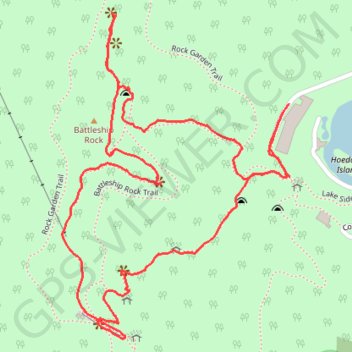
Name: Natural Bridge Trail, Laurel Bridge Trail and Battleship Rock Trail Loop trail, distance, elevation, map, profile, GPS track
Start: 2110, Hemlock Lodge Road, Powell County, Kentucky, 40376, United States (37.77753 -83.68065)
End: 2109, Hemlock Lodge Road, Powell County, Kentucky, 40376, United States (37.77750 -83.68068)
Coordinates: 37.77282 -83.68641 37.77935 -83.68063
Topography: Powell County topographic map, elevation, terrain
Other hiking, mountain biking, running and outdoor activity trails
Click on a trail to view its statistics, map and profile.
Natural Bridge and Battleship Rock Trail in Natural Bridge State Resort Park
United States > Kentucky > Powell County
Natural Bridge and Battleship Rock Trail offers hikers a fantastic experience of Kentucky's natural beauty. Along the route, you'll encounter the iconic Natural Bridge, a large sandstone arch with stunning views of the surrounding forest and cliffs. The trail continues to Battleship Rock, where you can…
Distance: 2.6 mi • Elevation gain: 627 ft • Maximum elevation: 1,257 ft