Thank you for supporting this site ❤️
Make a donation
Make a donation
Gear up for your next adventure:
As an Amazon Associate, this site earns from qualifying purchases at no extra cost to you.
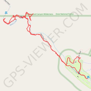
Red Reef and campground
- Distance: 2.3 mi
- Elevation gain: 564 ft
- Maximum elevation: 3,428 ft
- Elevation loss: 564 ft
- Minimum elevation: 3,199 ft
- Moving time: 1 h 8 m
- Moving speed: 2.0 mph
- Maximum speed: 8.3 mph
- Total time: 1 h 36 m
- Global speed: 1.4 mph
Interactive trail map
Thank you for supporting this site ❤️
Make a donation
Make a donation
Gear up for your next adventure:
As an Amazon Associate, this site earns from qualifying purchases at no extra cost to you.
Trail profile
- Distance: 2.3 mi
- Elevation gain: 564 ft
- Maximum elevation: 3,428 ft
- Elevation loss: 564 ft
- Minimum elevation: 3,199 ft
- Moving time: 1 h 8 m
- Moving speed: 2.0 mph
- Maximum speed: 8.3 mph
- Total time: 1 h 36 m
- Global speed: 1.4 mph
Thank you for supporting this site ❤️
Make a donation
Make a donation
Gear up for your next adventure:
As an Amazon Associate, this site earns from qualifying purchases at no extra cost to you.
About this trail
Name: Red Reef and campground trail, distance, elevation, map, profile, GPS track
Start: Anasazi, Washington County, Utah, United States (37.22327 -113.40401)
End: Anasazi, Washington County, Utah, United States (37.22330 -113.40386)
Coordinates: 37.22325 -113.41368 37.22943 -113.40386
Topography: Washington County topographic map, elevation, terrain
Thank you for supporting this site ❤️
Make a donation
Make a donation
Gear up for your next adventure:
As an Amazon Associate, this site earns from qualifying purchases at no extra cost to you.