Make a donation
Gear up for your next adventure:
As an Amazon Associate, this site earns from qualifying purchases at no extra cost to you.
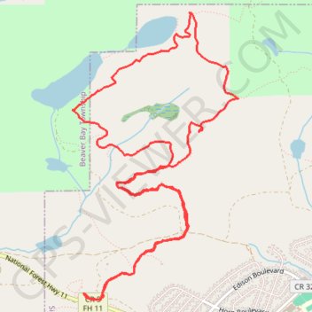
Bean and Bear Lakes Loop via Superior Hiking Trail in Superior National Forest
The Bean and Bear Lakes Loop offers hikers a delightful experience of Minnesota’s rugged natural beauty. As you wind through thick forests, you’ll encounter breathtaking vistas of the lakes, with expansive views of the surrounding hills and the tranquil waters below. The trail, with its moderate elevation changes and rocky terrain, culminates in a stunning overlook that is particularly magical during the fall when vibrant autumn colors surround the lakes. #Hiking #Loop #Lake #Overlook #Forest #Nature
- Distance: 6.9 mi
- Elevation gain: 1,217 ft
- Maximum elevation: 1,490 ft
- Elevation loss: 1,217 ft
- Minimum elevation: 1,083 ft
- Moving time: 2 h 54 m
- Moving speed: 2.4 mph
- Maximum speed: 4.8 mph
- Total time: 3 h 16 m
- Global speed: 2.1 mph
Interactive trail map
Make a donation
Gear up for your next adventure:
As an Amazon Associate, this site earns from qualifying purchases at no extra cost to you.
Trail profile
- Distance: 6.9 mi
- Elevation gain: 1,217 ft
- Maximum elevation: 1,490 ft
- Elevation loss: 1,217 ft
- Minimum elevation: 1,083 ft
- Moving time: 2 h 54 m
- Moving speed: 2.4 mph
- Maximum speed: 4.8 mph
- Total time: 3 h 16 m
- Global speed: 2.1 mph
Make a donation
Gear up for your next adventure:
As an Amazon Associate, this site earns from qualifying purchases at no extra cost to you.
About this trail
Name: Bean and Bear Lakes Loop via Superior Hiking Trail in Superior National Forest trail, distance, elevation, map, profile, GPS track
Coordinates: 47.29196 -91.30056 47.31419 -91.28157
Topography: Lake County topographic map, elevation, terrain
Make a donation
Gear up for your next adventure:
As an Amazon Associate, this site earns from qualifying purchases at no extra cost to you.