Make a donation
Gear up for your next adventure:
As an Amazon Associate, this site earns from qualifying purchases at no extra cost to you.
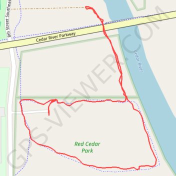
Red Cedar Park Loop
- Distance: 0.9 mi
- Elevation gain: 20 ft
- Maximum elevation: 925 ft
- Elevation loss: 20 ft
- Minimum elevation: 906 ft
- Moving time: 25 m 4 s
- Moving speed: 2.1 mph
- Maximum speed: 4.8 mph
- Total time: 29 m 8 s
- Global speed: 1.8 mph
Interactive trail map
Make a donation
Gear up for your next adventure:
As an Amazon Associate, this site earns from qualifying purchases at no extra cost to you.
Trail profile
- Distance: 0.9 mi
- Elevation gain: 20 ft
- Maximum elevation: 925 ft
- Elevation loss: 20 ft
- Minimum elevation: 906 ft
- Moving time: 25 m 4 s
- Moving speed: 2.1 mph
- Maximum speed: 4.8 mph
- Total time: 29 m 8 s
- Global speed: 1.8 mph
Make a donation
Gear up for your next adventure:
As an Amazon Associate, this site earns from qualifying purchases at no extra cost to you.
About this trail
Name: Red Cedar Park Loop trail, distance, elevation, map, profile, GPS track
Start: 948, 8th Street Southeast, Waverly, Bremer County, Iowa, 50677, United States (42.71277 -92.45993)
End: 949, 8th Street Southeast, Waverly, Bremer County, Iowa, 50677, United States (42.71268 -92.45993)
Coordinates: 42.71145 -92.46076 42.71485 -92.45688
Topography: Bremer County topographic map, elevation, terrain
Make a donation
Gear up for your next adventure:
As an Amazon Associate, this site earns from qualifying purchases at no extra cost to you.