Thank you for supporting this site ❤️
Make a donation
Make a donation
Gear up for your next adventure:
As an Amazon Associate, this site earns from qualifying purchases at no extra cost to you.
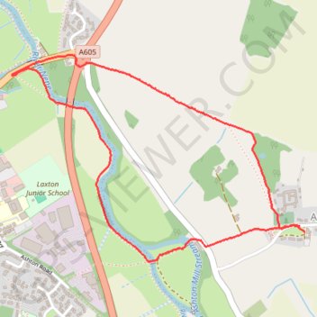
River Nene Loop from Ashton
- Distance: 2.1 mi
- Elevation gain: 82 ft
- Maximum elevation: 141 ft
- Elevation loss: 82 ft
- Minimum elevation: 66 ft
- Moving time: 53 m 5 s
- Moving speed: 2.4 mph
- Maximum speed: 3.6 mph
- Total time: 54 m 44 s
- Global speed: 2.3 mph
Interactive trail map
Thank you for supporting this site ❤️
Make a donation
Make a donation
Gear up for your next adventure:
As an Amazon Associate, this site earns from qualifying purchases at no extra cost to you.
Trail profile
- Distance: 2.1 mi
- Elevation gain: 82 ft
- Maximum elevation: 141 ft
- Elevation loss: 82 ft
- Minimum elevation: 66 ft
- Moving time: 53 m 5 s
- Moving speed: 2.4 mph
- Maximum speed: 3.6 mph
- Total time: 54 m 44 s
- Global speed: 2.3 mph
Thank you for supporting this site ❤️
Make a donation
Make a donation
Gear up for your next adventure:
As an Amazon Associate, this site earns from qualifying purchases at no extra cost to you.
About this trail
Name: River Nene Loop from Ashton trail, distance, elevation, map, profile, GPS track
Start: Ashton, North Northamptonshire, England, PE8 5LD, United Kingdom (52.48238 -0.44653)
End: The Green, Ashton, North Northamptonshire, England, PE8 5LD, United Kingdom (52.48214 -0.44622)
Coordinates: 52.48111 -0.46330 52.48843 -0.44622
Thank you for supporting this site ❤️
Make a donation
Make a donation
Gear up for your next adventure:
As an Amazon Associate, this site earns from qualifying purchases at no extra cost to you.