Užice: kanjon Đetinje, Đurića orlovi
- Distance: 8.7 mi
- Elevation gain: 2,201 ft
- Maximum elevation: 2,454 ft
- Elevation loss: 2,103 ft
- Minimum elevation: 1,342 ft
- Moving time: 3 h 33 m
- Moving speed: 2.4 mph
- Maximum speed: 5.8 mph
- Total time: 3 h 59 m
- Global speed: 2.2 mph
Interactive trail map
Trail profile
- Distance: 8.7 mi
- Elevation gain: 2,201 ft
- Maximum elevation: 2,454 ft
- Elevation loss: 2,103 ft
- Minimum elevation: 1,342 ft
- Moving time: 3 h 33 m
- Moving speed: 2.4 mph
- Maximum speed: 5.8 mph
- Total time: 3 h 59 m
- Global speed: 2.2 mph
About this trail
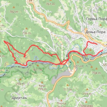
Name: Užice: kanjon Đetinje, Đurića orlovi trail, distance, elevation, map, profile, GPS track
Coordinates: 43.84801 19.77811 43.85826 19.83462
Other hiking, mountain biking, running and outdoor activity trails
Click on a trail to view its statistics, map and profile.
2022_Yu
Slovenia > Ajdovščina > Žapuže
Distance: 1,526.9 mi • Elevation gain: 105,144 ft • Maximum elevation: 6,398 ft