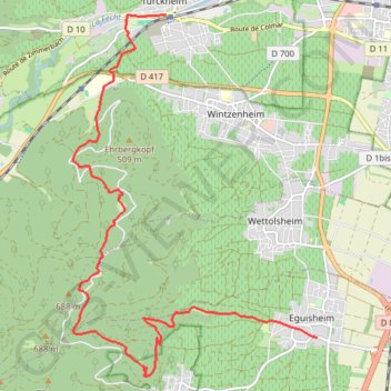
1. Eguisheim-Turckheim
- Distance: 8.4 mi
- Elevation gain: 1,726 ft
- Maximum elevation: 2,067 ft
- Elevation loss: 1,624 ft
- Minimum elevation: 682 ft
Interactive trail map
Trail profile
- Distance: 8.4 mi
- Elevation gain: 1,726 ft
- Maximum elevation: 2,067 ft
- Elevation loss: 1,624 ft
- Minimum elevation: 682 ft
About this trail
Name: 1. Eguisheim-Turckheim trail, distance, elevation, map, profile, GPS track
Coordinates: 48.03685 7.25961 48.08594 7.30930
Other hiking, mountain biking, running and outdoor activity trails
Click on a trail to view its statistics, map and profile.
Track vom: 2020-06-13 07:00
Germany > North Rhine-Westphalia > Kreis Wesel > Schermbeck
Distance: 422.5 mi • Elevation gain: 17,392 ft • Maximum elevation: 3,022 ft
Track vom: 2020-06-27 07:26
Germany > Bavaria > Landkreis Ostallgäu > Halblech
Distance: 427.6 mi • Elevation gain: 14,131 ft • Maximum elevation: 2,989 ft
La route des vins d'Alsace
France > Grand Est > Bas-Rhin > Strasbourg
Distance: 69.5 mi • Elevation gain: 2,126 ft • Maximum elevation: 919 ft
Riethoven naar Oostenrijk
Netherlands > North Brabant > Riethoven > Eind
Distance: 573.0 mi • Elevation gain: 44,715 ft • Maximum elevation: 6,224 ft
PT23BS1 Kiel → Lörrach
Germany > Schleswig-Holstein > Kiel
Distance: 650.4 mi • Elevation gain: 30,397 ft • Maximum elevation: 2,484 ft