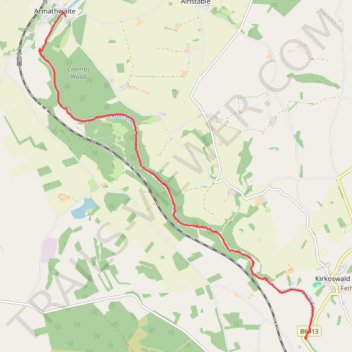
Kayak on River Eden
- Distance: 6.5 mi
- Elevation gain: 358 ft
- Maximum elevation: 256 ft
- Elevation loss: 427 ft
- Minimum elevation: 151 ft
- Moving time: 2 h 20 m
- Moving speed: 2.8 mph
- Maximum speed: 6.7 mph
- Total time: 4 h 13 m
- Global speed: 1.5 mph
Interactive trail map
Trail profile
- Distance: 6.5 mi
- Elevation gain: 358 ft
- Maximum elevation: 256 ft
- Elevation loss: 427 ft
- Minimum elevation: 151 ft
- Moving time: 2 h 20 m
- Moving speed: 2.8 mph
- Maximum speed: 6.7 mph
- Total time: 4 h 13 m
- Global speed: 1.5 mph
About this trail
Name: Kayak on River Eden trail, distance, elevation, map, profile, GPS track
Start: B6413, Lazonby, Westmorland and Furness, England, CA10 1BJ, United Kingdom (54.75536 -2.70089)
Coordinates: 54.75517 -2.77414 54.80701 -2.69867